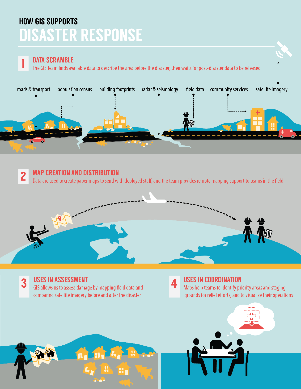
After disasters strike, updated maps are extremely important to emergency responders. These maps help us measure the damage, identify priority areas, navigate our way around damaged roadways, and more efficiently deliver aid to people in need. The maps can show us things like road quality, building damage, and whether rural areas are cut off from the aid delivery routes.
A History of Mapping for Disasters
The Red Cross used OpenStreetMap technology in 2012 to trach a cholera outbreak in Sierra Leone and then again in 2013 to assist Typhoon Haiyan survivors. After Typhoon Haiyan, emergency responders told us how much more efficiently they were able to work because of these maps. The Red Cross loaded the updated maps onto relief workers’ GPS devices—it not only saved them time navigating to villages while delivering relief supplies, but also helped teams to assess damages.
Mapping for Nepal
Red Cross and OpenStreetMap volunteers are now mapping areas in Nepal after the 7.8 magnitude earthquake hit on Saturday. Mappers are working hard tracing detailed mountainous terrain to help disaster responders measure the damage caused and deliver aid to people in need. When we deployed people to Nepal this week, we sent maps to use and share with other Red Cross team members on the ground.
Following the earthquake, the Humanitarian OpenStreetMap Team (HOT) tasked volunteers to map IDP (Internally Displaced People) camps from satellite imagery services provided by (or shared by) the State Department’s MapGive program.
“This collaboration is unprecedented,” said Samuel Estabrook, a GIS Analyst with International Services at the American Red Cross. “It’s wonderful. Now all this work has to be put to good use. Within the next few days and weeks we will analyze incoming data that’s a result of this thoughtful gesture by volunteers, organizations, and partners of the American Red Cross. Our tools and resources, given to us by trusting and kind donors and volunteers, are being deployed to and utilized in Nepal. We can only hope that our help will alleviate some of anguish cause by the earthquake.”
How You Can Help
OpenStreetMap works like Wikipedia, in that many people have their eyes on the same information. Volunteers are playing a huge part in making these maps, but more experienced mappers are checking their work, making wide-ranging edits, and identifying areas that have been undeserved.
To help with critical mapping efforts, visit http://tasks.hotosm.org. No experience is needed, just a computer and internet connection.
Learn more about how the American Red Cross is responding to the Nepal earthquake on redcross.org.